Sentiero Capo Milazzo - Laghetto di Venere
Raggiunta l’estremità del promontorio di Capo Milazzo percorribile in auto lungo la SP n. 74, Via S. Antonio, fino a raggiungere il parcheggio pubblico, a pochi passi si trova il cancello di accesso al Santuario di San Antonio da Padova, chiesa rupestre affacciata su un costone proteso sul mare ove il santo trovò rifugio dopo essere naufragato nel 1221. La chiesetta, scavata nella roccia, divenne luogo di culto e devozione, ed al suo interno, sull’altare, è posta una statua lignea del XVIII sec. raffigurante il Santo.
Dopo la visita al Santuario si risale sulla stradella che si inoltra in C.da Paradiso; qui l’accesso pedonale nell’area privata ove, percorrendo il sentiero della Baronìa (fondaz. Lucifero), si vede il Faro e si attraversa un centenario uliveto che si protende fino al promontorio ed alla sottostante ripida scogliera. La natura si presenta nella sua “mediterraneità” con le inflorescenze spontanee e profumate di Glebionis coronaria (crisantemo selvatico) e con i caratteristici fiori del cappero dal colore bianco e dagli stami rosso violacei.
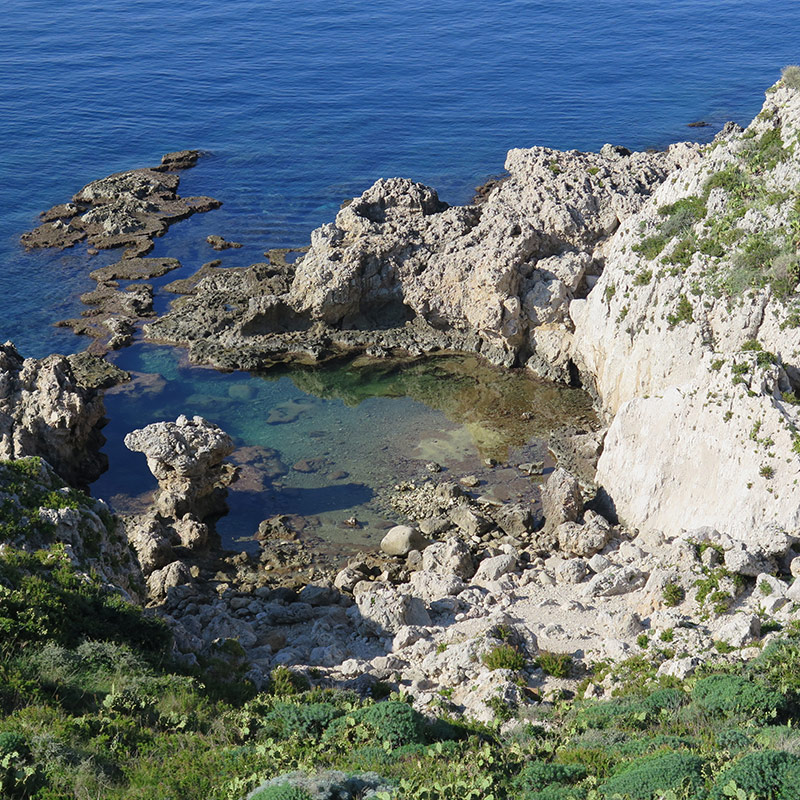
Continuando il percorso si giunge ad uno straordinario punto panoramico, con vista sulle isole Eolie, ove inizia un sentiero in cemento a gradoni che scende verso la costa. Un bivio conduce, scendendo ancora sulla destra, sull’estremità della penisola, verso l’attrattiva naturalistica di una piscina naturale, il Laghetto di Venere, anfratto di rocce e sassi su una vasca di acqua marina cristallina e calma. Lì si può fare un bagno rinfrescante ed avventurarsi con la maschera da sub fin’oltre il limite dell’insenatura, in mare aperto. La vista del fondale mediterraneo, in una zona protetta, è dei più spettacolari, fra pesci multicolori, molluschi e piante marine.
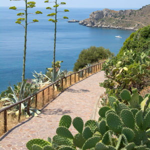
Risalendo sul sentiero già percorso si può ancora osservare dall’alto lo Scoglio della Portella, detto “il carciofo”, che si erge in mare di fronte il promontorio; poi si ritorna al precedente bivio e da qui può continuare il percorso passando sul tratto che costeggia la baia di S. Antonio. Dal bivio si segue il cartello verso una torre ottagonale del 1895 “Torre del Palombaro”, si scende fra stretti tornanti in terra battuta e piccole aree attrezzate, ove la vista panoramica sulla baia riempie di soddisfazione. Scendendo ancora, fra fichi d’india, ginestre ed agavi, si arriva sulla riva del mare, nell’antico “borgo dei pescatori” e qui si possono ancora vedere i resti di un vecchio fabbricato “tonnarella di Sant’Antonio” e ricoveri per le imbarcazioni.
Da qui il sentiero, panoramico con steccato in paletti di legno, si eleva dolcemente lungo la baia verso la sua conclusione: infatti esso si innesta sul marciapiede della strada provinciale a pochi metri dai ruderi della “Torre Longa”, cinquecentesca postazione militare di avvistamento costiero. Risalendo di qualche centinaio di metri lungo la provinciale, si ritorna al parcheggio del capo Milazzo, punto di partenza del nostro itinerario.
Percorso a piedi:
- lunghezza: 2,5 km
- durata: 2 ore ca.
- tipo: misto
- dislivello in salita: 80 m.
- punto più alto: 80 mt slm
- difficoltà: facile
(English)
CAPE MILAZZO TRAIL - POOL OF VENUS
Reaching the end of the promontory of Capo Milazzo drive along the SP No. 74, Via S. Antonio, until you reach the public parking lot, a few steps away is the access gate to the Sanctuary of St. Anthony of Padua, a rock church overlooking a ridge jutting out into the sea where the saint found refuge after being shipwrecked in 1221. The little church, carved into the rock, became a place of worship and devotion, and inside, on the altar, is an 18th-century wooden statue depicting the saint.
After visiting the sanctuary, one go up the little road that leads into C.da Paradise; here it is the pedestrian access into the private area where, following the path of the Baronia (fondaz. Lucifero), one sees the lighthouse and crosses a centuries olive grove that stretches out until the promontory and the steep cliff below. Nature presents itself in its "Mediterranean-ness" with the spontaneous, fragrant inflorescences of Glebionis coronaria (wild chrysanthemum) and the characteristic flowers of the white-colored caper with purplish-red stamens.
Continuing along the path we reach an extraordinary vantage point, with views of the Aeolian Islands, where a stepped concrete path begins, descending to the coast. A fork leads, descending still on the right, on the end of the peninsula, towards to the naturalistic attraction of a natural swimming pool, the Laghetto di Venere, a nook and cranny of rocks and stones over a pool of crystal-clear, calm sea water. There one can take a refreshing bath and venture with a diving mask as up to over far as the beyond the limit of the inlet, into the open sea. The view of the Mediterranean seabed, in a protected area, is of the most spectacular, among multicolored fish, mollusks and sea plants.
Going back up the path already traveled, one can still observe from above the Scoglio della Portella, known as "the artichoke," which rises into the sea in front of the promontory; then one returns to the previous junction and from here can continue the route by passing on the stretch that skirts the bay of S. Antonio. From the junction follow the sign toward an octagonal tower from 1895 "Torre del Palombaro," descending between narrow dirt hairpin bends and small picnic areas, where the panoramic view of the bay fills one with satisfaction. Descending further, among prickly pears, brooms and agaves, you arrive on the seashore, in the old "fishermen's village," and here you can still see the remains of an old building "tonnarella di Sant'Antonio" and shelters for boats.
From here the path, scenic with a wooden picket fence, rises gently along the bay toward its conclusion: in fact, it joins the sidewalk of the provincial road a few meters from the ruins of the "Torre Longa," a sixteenth-century military coastal lookout post. Climbing up a few hundred meters along the provincial road, we return to the parking lot of Cape Milazzo, the starting point of our itinerary.
Walking route:
- length: 2.5 km
- duration: 2 hours approx.
- type: mixed
- Uphill gradient: 80 m.
- highest point: 80 mt slm
- difficulty: easy