ALTOPIANO DELL'ARGIMUSCO
All’interno della Riserva Naturale Orientata del bosco di Malabotta, sui Monti Nebrodi, fra i 700 ed i 1200 metri di altitudine s.l.m., nel territorio dei comuni di Montalbano E., Tripi e Roccella Valdemone, si sviluppa l’Altopiano dell’ Argimusco, sito naturalistico ed archeologico fra i più caratteristici della provincia di Messina.
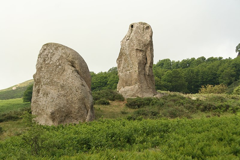
A circa 6 km. dal borgo di Montalbano si ergono una decina o più di giganteschi roccioni di arenaria quarzosa, “le Rocche”, che vengono apparentati ai menhir (forse la somiglianza maggiore è quella con il sito di Marcahuasi in Perù) assumendo le più bizzarre e fantasiose forme, modellate nei millenni dal vento e dall’acqua (e non dei megaliti realizzati dall’uomo).
Proprio per la loro somiglianza antropomorfa e zoomorfa vengono riconosciute la figura maschile e femminile, l’aquila, l’orante, la vasca, il sacerdote o guerriero, la scimmia, la torre o grande sedile e vari altri.
Questo sito rupestre nel corso dei secoli ha assunto aspetti mistici e religiosi, e nell’immaginario comune evoca riti e liturgie, esoterismo e magia, antichissime sepolture ed osservazioni astronomiche, pur mantenendo perennemente il fascino delle epoche passate e la bellezza dell’ambiente circostante e del panorama.
Percorso a piedi:
- lunghezza: 2,5 km
- durata: 2 ore ca.
- tipo: misto (a tratti circolare)
- dislivello in salita: 50 m.
- punto più alto: 1230 mt slm
- difficoltà: facile
(English)
PLATEAU OF ARGIMUSCO
Inside the Oriented Nature Reserve of the forest of Malabotta, in the Nebrodi Mountains, between 700 and 1200 meters above sea level, in the territory of the municipalities of Montalbano E., Tripi and Roccella Valdemone, develops the Argimusco Plateau, One of the most characteristic naturalistic and archaeological sites of the province of Messina.
At about 6 km. from the village of Montalbano rise about ten or more gigantic rocks of quartz sandstone, "Le Rocche", which are related to the menhirs (perhaps the greatest similarity is that with the site of Marcahuasi in Peru) assuming the most bizarre and imaginative forms, shaped over millennia by wind and water (and not man-made megaliths).
Precisely because of their anthropomorphic and zoomorphic resemblance, the male and female figure, the eagle, the orant, the rock carved basin, the priest or warrior, the monkey, the tower or great seat, and various others are recognized. This rock site over the centuries has taken on mystical and religious aspects, and in the common imagination it evokes rituals and liturgies, esotericism and magic, ancient burials and astronomical observations, while perpetually maintaining the charm of past eras and the beauty of the surrounding environment and landscape.
Walking route:
- length: 2.5 km
- duration: 2 hours approx.
- type: mixed (in parts circular)
- elevation gain: 50 m.
- highest point: 1230 m asl
- difficulty: easy