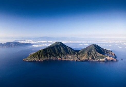
Santa Marina Salina
Santa Marina Salina – Monte Fossa delle Felci
Da via Belvedere si sale attraverso il sentiero che supera Serro Favoloro e Serro Cicirilla e giunge ad una biforcazione a quota 400 mt., d a qui, andando a destra, si segue il vallone del Castagno per raggiungere la carrabile che porta al rifugio di M. Rivi a quota 803 mt., a sinistra il percorso incrocia il vallone Batanà. Da qui si continua su un sentiero fortemente solcato a causa della natura del terreno vulcanico che subisce l’azione delle precipitazioni, dei venti e del passaggio dei numerosi escursionisti.
Il sentiero è caratterizzato dalla presenza di arbusti di erica e ginestra, da alberelli di corbezzolo dagli inconfondibili frutti rossi e gialli e fiori di cisto; giunti in quota, all’altezza della strada carrabile, la vegetazione mediterranea lascia il posto ai boschi di pino marittimo, ontano e castagno, frutto dell’opera di rimboschimento effettuata dal corpo forestale negli anni ’50.
Le felci formano il sottobosco della parte sommitale ed anche dell’interno del cratere del vulcano ormai spento da secoli; la loro estesa e suggestiva presenza ha determinato la denominazione “Fossa delle Felci”.
Abbandonato il sentiero e giunti sulla carrabile è possibile tagliare i numerosi tornanti attraverso un tracciato ripido che porta direttamente sulla sommità della montagna a quota 930 mt., il luogo più alto di tutto l’arcipelago eoliano, dal quale il panorama spazia in tutte le direzioni.
Effettuato il periplo del cratere si può scegliere di tornare ai centri abitati dal versante di Valdichiesa scendendo in direzione ovest verso il Santuario della Madonna del Terzito.
Malfa
Malfa è situata nella parte settentrionale dell'isola di Salina, alle pendici del Monte dei Porri e del Monte Rivi. È una zona fitta di vegetazione su un piccolo altopiano, con sbocco al mare. L'economia si basa sull'agricoltura (vite, uva passa, olive, capperi), artigianato, pesca (pesce spada)e turismo. Rinomata è la produzione di Malvasia. La frazione di Pollara risulta evidenziata nel famoso film “Il Postino” con Massimo Troisi. Da Semaforo e da Capo Faro si dipartono sentieri che salgono sulla montagna
Leni
Valdichiesa - Monte Porri - Semaforo di Pollara
Superato Valdichiesa, all’altezza di via Damice prendere la stradina che sale verso monte, tra le essenze tipiche delle Eolie: erica, corbezzolo, lentisco, di dimensioni modeste per i forti venti ed i prolungati periodi siccitosi; inoltre vi sono cisti dalle colorite infiorescenze e ginestre.
Sulla cima di Monte Porri a 860 mt. s.l.m. la vista spazia su tutto l’arcipelago sino alla costa siciliana; da qui inizia il lungo sentiero di Serra Pollara che guarda l’incantevole baia di Pollara con il villaggio, le falesie a picco sul mare e lo scoglio di fronte la spiaggia.
Il percorso un po’ accidentato giunge in località Semaforo dove spicca una vecchia lanterna, riferimento per i naviganti; da qui è possibile andare verso Pollara o dirigersi a destra verso Malfa.
Monte dei Porri è riserva naturale orientata assieme alla dirimpettaia Montagna delle Felci.
Salire da un versante e scendere dall’altro rende il percorso vario e affascinante.
(English)
Santa Marina Salina
Santa Marina Salina - Mountain Fossa delle Felci
From via Belvedere we climb to the path that goes beyond Serro Favoloro and Serro Cicirilla reaching a fork at 400 m a.s.l where, on the right, we follow the valley of the Chestnut until the road that leads to the refuge of M. Rivi at 803 m.
On the left the rout crosses the valley Batanà. From here we go along a path heavily streaked due to the nature of the volcanic soil that undergoes the action of the rainfalls and the winds.
The path is characterized by the presence of heather and gorse shrubs, saplings of red and yellow fruits and red rock flowers; once reached a height, at the height of the driveway, the Mediterranean vegetation gives way to the maritime pine forests, alder and chestnut.
The ferns form the undergrowth of the upper part and also at the interior of the crater of the Vulcan already extinct for centuries; the extension and the suggestive presence have determined the name of “Fossa delle Felci”.
Once left the trail and reached the driveway it is possible to cut through the many turns across the steep plot that leads directly on the top at an altitude of 930 m, the highest one of the Aeolian islands.
Once made the circumnavigation of the crater we may choose to return to the villages of the slope of Valdichiesa down in the direction of west towards the Sanctuary of Our Lady of Terzito.
Malfa
Malfa is located in the northern part of the island of Salina, at the foot of Mount Porri and Mount Rivi. It is a dense area of vegetation on a small plateau, with an outlet to the sea. The economy is based on agriculture (vine, raisins, olives, capers), handicrafts, fishing (swordfish) and tourism. Renowned is the production of wine. The hamlet of Pollara is highlighted in the famous film "Il Postino" with Massimo Troisi. From Semaforo and Capo Faro depart paths that go up to the mountain
Leni
Valdichiesa - Mount Porri - Semaforo di Pollara
Once exceeded Valdichiesa, at via Damice take the road that goes uphill, among the typical essences of the Aeolians: Heather, arbutus, mastic, of modes dimensions for the strong winds and prolonged drought; there are also cysts of colourful flowers and brooms.
On top of Mount Porri at 860 mt. a.s.l. with sweeping views over the archipelago to the Sicilian coast; from here it starts the long path of Serra Pollara that looks at the enchanting bay of Pollara with the village, the cliffs overlooking the sea and the rock in front of the beach.
The path a bit rough reaches the locality of Semaforo where stands an old lantern, a reference to sailors; from here it is possible to go towards Pollara or go to the right towards Malfa.
Mount of Porri is a natural reserve oriented along with the neighbour of Mountain of the Felci.
Climb one side and go down the other side makes the path varied and fascinating.